Sunday, July 22, 2012

Puri - Chennai - Puri Weekly Superfast Express Introduced by Southern Railways


INTRODUCTION OF PURI – CHENNAI – PURI WEEKLY SUPERFAST EXPRESS TRAINS

Southern Railways has announced a new Weekly Superfast Express between Puri - Chennai Central w.e.f. 22.7.2012 from Puri and 23.7.2012 from Chennai.

T.No.22859 Puri – Chennai Central Weekly Superfast Express will leave Puri at 17.30 hrs. on Sundays and arrive Chennai Central at 14.55 hrs. on Mondays. T.No.22860 Chennai Central – Puri Weekly Superfast Express will leave Chennai Central at 16.15 hrs. on Mondays and arrive Puri at 15.05 hrs. on Tuesdays. The composition of the trains will be 1 AC 2-tier, 1 AC 3-tier, 9 Sleeper Class, 4 General Second Class and 2 luggage-cum-brake van coaches. The trains will stop at Khurda Road, Balugaon, Chatrapur, Brahmapur, Sompeta, Palasa, Srikakulam Road, Vizianagaram, Visakhapatnam, Samalkot, Rajahmundry, Eluru, Vijayawada, Tenali, Ongole, Nellore, Gudur, Nayudupeta and Sullurupeta.

Advance reservation for the above trains will commence on 19.7.2012.

Extension of Surat - Varanasi- Surat Tapti Ganga Express upto Chhapra


EXTENSION OF SURAT- VARANASI- SURAT TAPTI GANGA EXPRESS TRAIN UPTO CHHAPRA

For the convenience of the rail passengers,Northern Railways have decided to extend the run of train no. 12945/12946 Surat- Varanasi- Surat Tapti GangaExpress train (five days a week) upto “Chhapra” station from 20.7.2012 as per the following programme:

The 12945 Surat- Varanasi Tapti GangaExpress train will depart from Surat station on every Monday, Wednesday, Thursday, Friday and Sunday at 09.35 a.m. to reach Chhapra railway station at 06.35 p.m. the next day. In the return direction, the 12946 Varanasi- Surat Tapti GangaExpress train will depart from Chhapra railway station on every Tuesday, Wednesday, Friday, Saturday and Sunday at 09.00 a.m. to reach Surat railway station at 06.50 p.m. the next day.

The 12945/12946 Surat- Varanasi- SuratTapti GangaExpress train will stop at Jaunpur, Shahganj, Azamgarh, Mau and Ballia stations enroute in both the directions on extended route from Varanasi to Chhapra.

With effect from 15.11.2012, the number of 12945/12946 Surat- Varanasi- Surat Tapti GangaExpress will be changed to 19045 when departing from Surat and 19046 when departing from Chhapra from 16.11.2012.

Sunday, July 15, 2012

Central Railways Introduces New Weekly Super Fast Express between Lokmanya Tilak Terminus and Vishakapatnam


Central Railways has annouced to introduce 22847 / 22848 Vishakapatnam - Lokmanya Tilak Terminus, a New Weekly Super Fast Express train w.e.f. 17.07.2012 Ex LTT and w.e.f. 15.07.2012 Ex Vishakapatnam. The details of commencement of regular services are as under-

22848 Weekly Superfast Express train will leave Lokmanyan Tilak Terminus at 00.15 hrs o­n every Tuesday (midnight of Mon/Tue) w.e.f. 17.07.2012 and arrive Vishakapatnam at 05.30 hrs next day.

22847 Weekly Superfast Express train will leave Vishakapatnam at 08.30 hrs o­n every Sunday w.e.f. 15.07.2012 and arrive Lokmanya Tilak Terminus at 13.35 hrs next day.

Halts: Kalyan, Nasik Road, Manmad, Bhusaval, Akola, Badnera, Wardha, Nagpur, Gondia, Durg, Raipur, Mahasamund, Khariar Road, Kantabanji, Titlagarh, Kesinga, Muniguda, Rayagada, Parvatipuram Town, Bobblli Jn, Vizianagaram stations.

Composition: o­ne AC-2 Tier, o­ne AC-3 Tier, 6 Sleeper class, 6 General Second class, 2 General second class cum Luggage/Brakevans.

Reservation: Bookings for Train No. 22848 will open from 16.7.2012.

Western Railways Introduces new trains between Bandra (T) – Bikaner Weekly Superfast Express


Bandra (T)–Bikaner Weekly Superfast Express (From 17/7/12 Ex Bandra (T))

Train No.22474 Bandra (T) - Bikaner Weekly Superfast Express will leave Bandra (T) at 14.35 hrs o­n every Tuesday from 17th July, 2012 and reach Bikaner at 12.35 hrs, the next day.

Similarly, in return direction Train No. 22473 Bikaner – Bandra (T) Weekly Superfast Express will leave Bikaner at 14.55 hrs o­n every Monday from 23rd July, 2012 and reach Bandra (T) at 12.45 hrs, the next day.

The train will have AC 2-tier, AC 3-tier, Sleeper class and second class general coaches.

The train will halt at Borivali, Valsad, Navsari, Surat, Bharuch, Vadodara, Anand, Nadiad, Ahmedabad, Mehesana Jn., Unjha, Sidhpur, Palanpur, Abu Road, Marwar Jn., Pali Marwar, Luni, Jodhpur, Merta Rd., Nagaur and Nokha stations in both directions.

Northern Railways announces new weekly trains between between Bandra T. – Delhi Sarai Rohilla| Train no. 19029/19030 Bandra T.- Delhi Sarai Rohilla- Bandra T. (weekly) Express

As announced in the Rail Budget 2012-2013, the new train no. 19029/19030 Bandra T.- Delhi Sarai Rohilla- Bandra T. (weekly) Express will be introduced between Bandra T.- Delhi Sarai Rohilla as per the following programme:-

The 19030 Delhi Sarai Rohilla- Bandra T. (weekly) Express train will depart from Delhi Sarai Rohilla from 19.07.2012 on every Thursday at 03.50 p.m. to reach Bandra T. at 05.10 p.m. the next day. In the return direction, the 19029 Bandra T.- Delhi Sarai Rohilla (weekly) Express train will depart from Bandra T. from 18.07.2012 on every Wednesday at 12.25 p.m. (noon) to reach Delhi Sarai Rohilla at 01.20 p.m. the next day.

Consisting of One A.C. 2 Tier, Two A.C. 3 Tier, Seven Sleeper class, Six Second class and Two Second class Cum Luggage van coaches, the 19029/19030 Bandra T.- Delhi Sarai Rohilla- Bandra T. (weekly) Express train will stop at Boriveli, Vapi, Surat, Bharuch, Vadodara, Anand, Nadiad, Ahmedabad, Sabarmati, Mehsana, Palanpur, Abu Road, Sirohi Road, Falna, Rani, Ajmer, Kishangarh, Phulera, Ringus, shri Madhopur, Nim ka Thana, Narnaul, Rewari, Gurgaon, Delhi Cantt. stations enroute in both the directions.

Sunday, July 8, 2012

Sainagar Shirdi-Mysore Weekly Express Announced

INTRODUCTION OF SAINAGAR SHIRDI - MYSORE WEEKLY EXPRESS

Central Railways has announced to introduce a new Weekly Express train between Sainagar Shirdi & Mysore via Daund, Solapur, Bijapur, Guntakal, Bangalore.

The details are as under:

16217 Mysore – Sainagar Shirdi Weekly Express will leave Mysore o­n every Monday at 05.30 hrs with effect from 09.07.2012 and arrive Sainagar Shirdi at 11.30 hrs next day i.e. Tuesday.

16218 Sainagar Shirdi – Mysore Weekly Express will leave Sainagar Shirdi o­n every Tuesday at 23.55 hrs with effect from 10.07.2012 and arrive Mysore at 06.55 hrs o­n third day i.e. Thursday.

Halts: Puntamba, Belapur, Ahmednagar, Daund, Kurduwadi, Solapur, Bijapur, Bagalkot, Gadag Jn, Koppal, Hospet, Bellary Jn, Guntakal Jn, Anantpur, Dharmavaram, Hindupur, Yelanhanka, Bangalore Cantt., Bangalore City, Kengeri and Mandya.

Composition: Two AC Two Tier, Two AC Three Tier, 12 Sleeper Class, Three General Second Class, Two General Second Class cum Guards Break Van. Total 21 Coaches.

RESERVATION: Bookings for Train no. 16218 will be opened from 08.07.2012 at all PRS locations.

SURAT-MALDA TOWN WEEKLY EXPRESS ANNOUNCED


For the convenience of passengers, Ministry of Railways – Western Railways has announced a new weekly train 13425/13426 between Surat and Malda Town.

Train No. 13426 Surat-Malda Town Weekly Express will leave Surat at 12.50 hrs every Monday from 09th July, 2012. It will reach Malda Town at 06.00 hrs the third day. Similarly, Train No. 13425 Malda Town-Surat Weekly Express will depart at 12.50 hrs from Malda Town every Saturday from 7th July, 2012 and reach Surat at 04.50 hrs o­n the third day.

The train will halt at Nandurbar, Amalner, Jalgaon, Bhusaval, Malkapur, Akola, Badnera Jn, Wardha Jn, Nagpur, Gondiya, Durg, Raipur, Bilaspur, Jharsuguda, Raurkela, Ranchi, Muri, Bokaro Steel City, Dhanbad, Asansol, Durgapur, Siuri, Rampur Hat, Pakur and New Farrakka in both the directions.

It consists of AC 2 Tier, AC 3 Tier, Sleeper & Second Class General coaches.
The booking of Train No. 13426 Surat – Malda

WEEKLY SUPERFAST EXPRESS TRAINS BETWEEN SHALIMAR – CHENNAI CENTRAL – SHALIMAR

Southern Railways has announced to introduce a new Superfast Weekly Express will be introduced between Shalimar and Chennai Central on 3.7.2012 ex. Shalimar and on 5.7.2012 ex. Chennai.
T.No.22825 Shalimar – Chennai Central Weekly Superfast Express will leave Shalimar at 12.20 hrs. on Tuesdays and arrive Chennai Central at 17.00 hrs. on Wednesdays.T.No.22826 Chennai Central – Shalimar Weekly Superfast Express will leave Chennai Central at 16.15 hrs. on Thursdays and arrive Shalimar at 21.30 hrs. on Fridays.The composition of the trains will be 1 AC 2-tier, 2 AC 3-tier, 9 Sleeper Class, 4 General Second Class and 2 luggage-cum-brake van coaches. The trains will stop at Santragachi, Kharagpur, Jaleswar, Balasore, Bhadrak, Jajpur Keonjhar Road, Cuttack, Bhubaneswar, Khurda Road, Brahmapur, Palasa, Vizianagaram, Visakhapatnam, Samalkot, Rajahmundry, Eluru, Vijayawada, Ongole, Nellore, Gudur, Nayudupeta and Sullurupeta.

Saturday, July 7, 2012

Western Railway Announces Okha – Jaipur Weekly Express

For the convenience of passengers, Ministry of Railways has decided to introduce a new weekly train 19573/19574 between Okha and Jaipur.

Train No. 19573 Okha-Jaipur Weekly Express will leave Okha at 19.20 hrs every Monday from 09th July, 2012. It will reach Jaipur at 15.15 hrs the next day. Similarly, Train No. 19574 Jaipur-Okha Weekly Express will depart at 16.40 hrs from Jaipur every Tuesday and reach Okha at 13.45 hrs on the next day.

The train will halt at Dwarka, Khambhaliya, Jamnagar, Hapa, Rajkot, Surendranagar, Viramgam, Mahesana, Palanpur, Abu Road, Jawai Bandh, Falna, Marwar, Sojat Road, Beawar, Ajmer, Kishangarh and Phulera in both the directions.

It consists of AC 2 Tier, AC 3 Tier, Sleeper class & Second Class General coaches.

The booking of Train No. 19573 Okha - Jaipur Weekly Express will open from 8th July, 2012.

Western Railways Announces Porbander – Secunderabad Weekly Express via Vasai


WRINTRODUCES PORBANDER-SECUNDERABAD

WEEKLY EXPRESS VIA VASAI

For the convenience of passengers, Ministry of Railways has decided to introduce a new weekly train 19202/19201 betweenPorbander and Secunderabad via Vasai Rd station.

Inaugural run of Train No 19202 Porbander–Secunderabad Weekly Express will be o­n 9th July 2012 from Porbander at 15.00 hrs to reach Secunderabad at 4.00 hrs o­n Wednesday. Thereafter, o­n its regular run from 16th July 2012, Train No. 19202 Porbandar - Secunderabad Weekly Express will depart from Porbandar at 23.55 hrs o­n every Monday and reach Secunderabad at 10.30hrs. o­n Wednesday.

Similarly, Train No. 19201 Secunderabad - Porbandar Weekly Express will depart from Secunderabad at 15.00 hrs o­n every Wednesday and arrive Porbandar at 00.10 hrs. o­n Friday from 11 thJuly, 2012.

The train will have AC II tier, AC III tier, sleeper class and General II class coaches.

The inaugural and regular halts of the train will be at Wansjalia, Jamnagar, Hapa, Rajkot, Surendranagar, Viramgam, Ahmedabad, Nadiad, Anand, Vadodara, Ankleshwar, Surat, Valsad, Vapi, Boisar, Vasai Road,Bhivandi Road, Kalyan, Karjat, Lonavala, Pune, Daund, Sholapur,Gulbarga, Wadi, Tandur and Begampet stations in both directions.

On the Inaugural run Train No 19202 Porbander-Secunderabad will reach Vasai o­n Wednesday at 10.00hrs and depart at 10.10hrs. Similarly, thetrain during its regular run will reachVasai every Wednesday at 18.20 hrs and depart at 18.25 hrs. o­n its regular return journey Train No.19201 will reach Vasai o­n Thursday at 6.10 hrs and depart at 6.15 hrs .

Booking for inaugural run of Train No 19202 opens o­n 8th July 2012 and for regular run opens o­n 10th July 2012.


Nainital Tourism | Nainital Tourist Attractions | Uttrakhand Hill Stations | Nainital Lake Valley Singhtseeing | Tourist Attraction around Nainital


Nainital


Nanital is 34 kms from Kathgodam, the nearest railway station located in the foothill, the gateway of the Kumaon Hills, and is around 336 Kms from National Capital Delhi. Nainital is also known as Lake District of India. Nainital is set in a valley containing a pear-shaped lake, approximately two miles in circumference, and surrounded by mountains. Nainital is a glorious hill station for tourism in Uttranchal, which was discovered by Lord Barron, a Britisher in 1841 and is located at a height of 6, 350 feet. In winter Nainital has freezing cold temperature which falls sometimes even below zero. It is surrounded by mountains on three sides. The first one is Naina (2615 meters) the second is Deopatha (2438 meters) and the third is Ayarpatha (2278 meters). Naina is the highest mountain among the three. Every year during December to February Nainital hill station gets its annual snowfall. Summer season is also very cool in Nainital. The highest temperate is not more than 26 degrees centigrade. Thus most tourists prefer to come at summer to explore Nainital tourism.

Nainital is named for its beautiful lake “Naini” and it is the base for tourism at here. This lake is called Naini because it look like eye shape. This Lake is famed among the visitors, tourists and nature lovers for yachting and boating. The southern end area of the lake is called Tallital and the northern end area is called Mallital. Both the areas have pretty cottages, luxuries hotels, villas, restaurants, food jones, shopping centers, game parlors and luxury shops. Other place, Naina Peak (6 kms) an other popular picnic spot is at a height of 2,610 metres. Fron the Naina Peak one can have breathtaking view of the Himalayas and entire lake region down the hill. Among the various temples, Naina Devi Temple is most famous and is situated on the northern shore of Naini Lake. The presiding goddess of this temple is “Maa Naina Devi”. Tourists visiting Nainital could also enjoy the Ropeway which is established by Kumaon Mandal Vikas Nigam. It is one of the advanced ropeways of India. The Ropeway is controlled electronically and mechanically both. It is used to carry 12 persons in a single time. Hanumangarhi located at distance of 3.2 kms from the city is famous for the Hanuman temple and the spectacular sun-set view from here.

Naina Devi Temple: The temple is located on the northern shore of Naini lake. The rpesiding deity of the temple is Maa naina Devi respresented by two Netras or eyes.This temple is special for local people as it has some spiritual values. Alongwith the the deity of Naina Devi there are the deities of Mata Kali and Lord Ganesha. It is believed to be one of the 64 Shaktipeetas, where one of the body parts of Goddess Sati fell. In Nainital, the eyes (naina) of the Goddess are assumed to have fallen. During the religious festivals, this temple becomes the first choice for local people. Naina Devi's temple was initially constructed in the 15th Century. The shrine of Naina Devi is a must visit for devout Hindus. and was reconstructed after being destroyed in the the 1880 landslide. The celebration with very good decoration makes the moment special in festivals.

Aerial Ropeway: Aerial Ropeway is one the main attraction of Nainital. This ropeway starts from from Mallital, the upper corner of lake, and snow view point. The spectacular view of the mountains and hills of Himalaya from this point is amazing. This could be the best moment of life by viewing the high hills of Indian ranges.

Nainital Zoo: The Zoo is located around 1 km from the main nainital township and is set up in a sprawling open area.  Its name has been changed to Govind-Ballabh-Pant High Altitude Zoo.

Tiffin Top: The well Tiffin Top is located at 4 KMs  up from Nainital. Normally tourists are to walk the crawling road to the top along the rugged hill side. This road ends at the top of hill and then suddenly tourists find themselves amidst the paranoia of vast Himalayan hills and nearby country view.  Dorothy seat a memorial to an English lady painter Dorothy Kellet build by her husband an admirers after her death here.

Naina Peak: Naina peak is the highest peak of the town, at an altitude of 2615 mts above sea level and at a distance of 6 Kms from the town. It is also known as Cheena Peak. Form the top of this peak, tourist enjoys the vast view of Himalayas on the Horizon. The top offers a full view of Himalaya on one side and the tiny lake of the Nainital town in its full beauty on the other side. It is the highest peak point of Nainital and can be visited by travelling. Pony or Horses can be hired to visit this peak either from Snow view or from Mallital.

Governor House: Raj Bhavan which is also known as Governor House, was constructed in 1899 by F. W. Stevens as residence of the Governor of North West Province. In British rule, this house was used as the summer residence of the Governor of British.  Now Raj Bhavan is the official accommodation of Governor (Uttaranchal).State guests coming to Nainital also use it for their stay. State employees are also enjoying this house in vacations.


Snow View Point: This is probably the most easily accessible hill top among the other hill tops through ropeway. The place is also connected by road and tourist could drive up to the top of hill. Snow view as the name suggests offers an indescribably beautiful and breath taking picture of the glittering snows of Himalyas. Nanda Devi, Trishul Choti, viewpoint and Nanda Kot are some other higher ranges where people can enjoy the view of mountains.

Caves Garden: This is the latest addition in the list of numerous tourism spots in Nainital. It is located in Sukha Tal around one Km from Mallital very near to Kumaun University Campus.

Hanuman Garhi: Hamuman Garhi is temple located around 3.5 km form the town. It is constructed at a height of 1955 meters from the sea level.  Hanuman Garhi is a religious centre and famous for its sun set view .One can go to Hanuman Garhi by taxi, bus or even on foot from Nainital .It has a temple complex presiding deity being Lord Hanuman besides Ram and Shiva. At the instance of Neem Karoli Baba around 1950 these temples were built.

Some more attractive places of Nainital are Land's End, Gurney House, Aryabhatta Research Institute of Observational Sciences, St. Johns Church, and Kilbury. These spots are beautifully maintained by the government of Uttarakhand, and visitors can enjoy the accommodation at various hotels available at Nainital. Booking for a hotel is possible through online as well because lots of tourism departments are providing the services for Nainital tour.

Places of Interest around Nainital

Bhimtal Lake: Bhimtal is 25 kms far from Nainital and 11 Kms. from Bhowali at an altitude of 1370 mts. The famous five Pandavas of ‘Mahabharata’ came there and one of them named “Bhim” killed a devil on this place. So it is called Bhimtal. The main attraction of this place is a beautiful lake with its grandeur size of more than Nainital lake an island in the center of the lake. This lake offers Boating, swimming and fishing. All luxuries facility for the tourist is available here. The local bus stand and taxi stand is located nearby to the lake. The tourist from here could go by road to Naukuchiatal or to Kathgodam, the nearest railway station, located at 21 Km from here. There is a 17th century Bhimeshwar temple complex along the 40 feet high dam.

Naukuchia Lake: It is 4 kms far form Bhimtal and 26 kms from Nainital at 1220 mts from sea level. A clean and beautiful lake within the surrounding picturesque valley offers very relaxing feelings to the visiting tourists. This lake is called so because of its nine corners. Migratory birds flock to the lake. This is an ideal place for relaxation and to spend your holidays.  Additionally, there is ample scope for rowing, paddling or yachting.

Mukteshwar (50 kms): This small hill station amidst thick wooded forest affords majestic view of the Himalayas and located at an altitude of 2286 mts and is 51 Kms from Nainital. Surrounded by fruit orchards and thick coniferous forest it was developed by the Britishers as research and education institute (IVRI) in 1893. Nearby is a stone hole of Chauli Ki Jali, dedicated to Lord Shiva.

Corbett National Park: The magnificent park established way back in 1936, is one of the best known sanctuaries of India. It is named after Jim Corbett, the famous hunter author and conservator.

Other userful destinations:


Monday, July 2, 2012

India Western Ghats now covered in World Heritage Sites; 17 nations favour India at World Heritage Committee meeting; Western Ghats Finds its way in World Heritage Site


The Western Ghats has made it to the coveted list of World Heritage Sites. The World Heritage Committee, meeting at St. Petersburg in Russia, decided to inscribe 39 serial sites of the Western Ghats on the World Heritage List on Sunday night.

“The Western Ghats was inscribed under criteria 9 and 10 of the Operational Guidelines of the World Heritage Convention,” Vinod B. Mathur, Dean of the Wildlife Institute of India, told The Hindu from Russia.

Criterion nine of the guidelines deals with properties which are “outstanding examples representing significant ongoing ecological and biological processes in the evolution and development of terrestrial, freshwater, coastal and marine ecosystems and communities of plants and animals.” Criterion 10 is relevant for “those properties which contain the most important and significant natural habitats for in-situ conservation of biological diversity, including those containing threatened species of outstanding universal value from the point of view of science or conservation.”

“The discussion on the Ghats witnessed representatives from 17 nations — Algeria, Cambodia, Columbia, Estonia,, Ethiopia, Iraq, Japan, Malaysia, Mali, Mexico, Qatar, Russia, Senegal, Serbia, South Africa, the UAE and Thailand —coming out strongly in favour of India. The Indian delegation aptly responded to a range of questions, clarification and amplifications sought by the members of the World Heritage Committee,” Dr. Mathur said in a communication.

Sunday, July 1, 2012

Jammu & Kashmir Valley Tourism Attractions | Summer cool destination Ladakh Valley | Kashmir - Leh Trekking | Leh Valley places to visit | Kargil - Valley of Flower visit | Zanskar Valley Visit | Nubra Valley - Ladakh places of Tourism


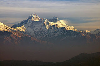
Jammu and Kashmir is southernmost state of India and situated mostly in the Himalayan Mountains. Jammu and Kashmir shares its borders with, states of Himachal Pradesh and Punjab of India to the south, China and Afghanistan to the Northeast and Pakistan administered territories to the West and Northwest respectively. Jammu and Kashmir consists of three regions namely Jammu, Kashmir Valley and the Ladakh. Jammu & Kashmir - a distinct land has enriched both travelers and people by multifaceted culture, geography and history blend with the unsurpassed natural beauty in all the three regions. Srinagar is the summer capital of the state and Jammu is the winter capital. This shifting of capital’s during winter was started with the Maharaja's of Dogra Rule and continues till now, and so both the cities are quite developed and have many tourist attractions. Once considered as the center of Hinduism and Buddhism many Sufi saints and sages have Kashmir as their birth place. While the Kashmir valley is known for its beautiful mountainous landscape, the lakes and blue valleys rising to alpine passes, the Jammu’s region is abode of gods and goddesses for which it bears the name, 'city of temples'. The region has broadened the spheres of pilgrimage tourism for entire State. At the same time Ladakh, a living centre of Buddhism, possesses mystique landscape and rugged pinnacles lit up by the colorful traditions of the people, it is a dream of adventurers and explorers.

Ladakh

Ladakh also known for land of high passes is the largest province within the region of Jammu and Kashmir covering approximately 60,000 square miles (100,000 sq. km). It is surrounded and bisected by some of the highest mountain ranges in the world. Part of Ladakh, Gilgit-Baltistan, is included in Pakistan territory.  Ladakh region is situated at the western edge of the Tibetan plateau, lies between the mighty Karokaram mountain range in the north and the Great Himalayas in the South. Running in a generally northwest to southeast direction through Ladakh, the great Himalayan Range separates the Vale of Kashmir from Ladakh. The height of these ranges prevents rain clouds from crossing into Ladakh and as a result, Ladakh receives only about 2 inches (5 cm) of rain per year. The aridity of the area is immediately apparent to the visitor, with Ladakh's long vistas of mountains without vegetation and valleys with only a few oases of green. It is one of the most sparsely populated region in Jammu and Kashmir. Landscape of Ladakh has been modified and sculpted into the spectacular shape by the wind and the erosion over the centuries. The Ladakh range has no major peaks; its average height is a little less than 6,000 m (19,700 ft), and few of its passes are less than 5,000 m (16,400 ft). The altitude in Ladakh ranges from a close to the 11,350 feet (3,500 m) and some of the surrounding peaks reach height of  22,500 feet (7,000 m).  It is rightly called “the broken moonland” and “land of endless discovery”.

Historically, the region included the Baltistan (Baltiyl) valleys, the Indus Valley, the remote Zangskar, Lahaul and Spiti to the south, Aksai Chin and Ngari, including the Rudok region and Guge, in the east, and the Nubra Valleys to the north. Present Ladakh borders Tibet to the east, the Lahaul and Spiti to the south, the Vale of Kashmir, Jammu and Baltiyul regions to the west, and the trans–Kunlun territory of Xinjiang to the far north. Ladakh is renowned for its remote mountain beauty and culture. It is sometimes called "Little Tibet" as it has been strongly influenced by Tibetan culture.

Ladakh is a high altitude desert as the Himalayas create a rain shadow, denying entry to monsoon clouds. The main source of water is the winter snowfall on the mountains. Dras, Zanskar and the Suru Valley on the Himalaya's northern flanks receive heavy snow in winter, this feeds the glaciers from which melt water, carried down by streams, irrigates the fields in summer. For the rest of the region, the snow on the peaks is virtually the only source of water. As the crops grow, the villagers pray not for rain, but for sun to melt the glaciers and liberate their water.


In the past Ladakh gained importance from its strategic location at the crossroads of important trade routes, but since the Chinese authorities closed the borders with Tibet and Central Asia in the 1960s, international trade has dwindled except for tourism. Since 1974, the Government of India has successfully encouraged tourism in Ladakh. Since Ladakh is a part of strategically important Jammu and Kashmir, the Indian military maintains a strong presence in the region.

The Indus River runs through Ladakh and the 30-mile (50 km) stretch of the Indus River Valley between Spitok gompa (near Leh airport) and Hemis gompa is the heartland of Ladakh. Here are scattered some of the finest gompas in the region and here also is the town of Leh, the capital of Ladakh. It is one of the few remaining abodes of Budhism in South Asia, including the Chittagong Hill Tracts, Bhutan and Sri Lanka; a majority of Ladakhis are Tibetan Buddhists and the rest are mostly Shia Muslims.

The main places of attractions are Leh District, Kargil river valleys, Zanskar range of mountains and Nuabra Valley.

Leh

Leh was once the capital of the Himalayan kingdom of Ladakh, is now a District in the state of Jammu and Kashmir, India and is towards the eastern parts of Jammu and Kashmir. Leh, with an area of 45,110 square km, is the second largest district in the country, after Kutch, Gujarat, in terms of area. The region gets its water from the Zanskar River, which flows into the Indus River just below.


The town is still dominated by the the nine-storey, now ruined, Leh Palace (Namgyal Palace) former mansion of the royal family of Ladakh, and the Namgyal Tsemo (Vicotry peak), built by Tashi Mamgyal on his victorious reunification of the Upper and Lower Ladakh. Leh is at an altitude of 3524 metres (11,562 ft), and connects via National Highway 1D connects it to Srinagar in the southwest and to Manali in the south via Leh-Manali Highway.

In the later period, Leh became an important center for trade in Central Asia. Leh remained merely a headquarter of Ladakh district until 1974, when Ladakh was opened for foreign tourists. Over the period, after its opening by Government of India for tourists, Leh became the centre for tourism related activities in the region.

Leh in India is a beautiful destination with so many attractions and is the center of Tibeto-Buddhist Culture for ages. Its colorful gompas have attracted the devout Buddhists from all over the globe. Besides, it is also a favorite hiking locale and is known for some of the best hikes in the country. Travel to leh this vacation to enjoy its mystic beauty, nut before that acquaint yourself a little bit about the past and present of Leh India.

Leh is connected to the rest of India by two high-altitude roads both of which are subject to landslides and neither of which are passable in winter when covered by deep snows. The National Highway 1D  from Srinagar via Kargil is generally open longer. The Leh- Manali Highway can be troublesome due to very high passes and plateaus, and the lower but landslide-prone Rohtang Pass near Manali.

SrinagarLeh Highway 1D: The overland approach to Ladakh from the Kashmir valley via the 434-km. The Srinagar- Leh road typically remains open for traffic from June to October/November. The most dramatic part of this road journey is the ascent up the 3,505 m (11,500 ft.) high Zoji-la, a tortuous pass in the Great Himalayan Wall. The Jammu & Kashmir State Road Transport Corporation (JKSRTC) operates regular Deluxe and Ordinary bus services between Srinagar and Leh on this route with an overnight halt at Kargil. Taxis (cars and jeeps) are also available at Srinagar for the journey.

Manali – Leh Highway: Since 1989, the 473-km Manali-Leh road has been serving as the second land approach to Ladakh. Open for traffic from June to late October, this high road traverses the upland desert plateaux of Rupsho whose altitude ranges from 3,660 m to 4,570 m. There are a number of high passes en route among which the highest one, known as Tanglang La, is sometimes (but incorrectly) claimed to be the world’s second highest motorable pass at an altitude of 5,325 m. (17,469 feet).

The places of attraction in Leh are:

Shanti Stupa.

Leh Palace.

Leh Trekking Trails.

War Museum.

Chamba Temple.

Jama Masjid.

Jo Khang Gompa.

Namgyal Tsemo Gompa.

Sankar Gompa.

Stock Palace.

The Victory Tower.

Zorawar Fort.

Kargil

The western parts of Ladakh comprising the river valleys, which are drained and formed by the Himalayan tributaries of the high Indus, constitute Kargil District. Kargil, the second town of Ladakh, is situated on the Suru River which flows at around 10,000 feet hight. Two other rivers that meet here are Drass and Wakha Chu.


Kargil town (2,704 m), situated midway between Srinagar (204 Kms) and Leh, (234 kms) on the Srinagar-Leh highway, is the second largest urban centre (approx. 8,000 inhabitants) of Ladakh and headquarters of Kargil district. Visible all around are lush green fields of barley and wheat, vegetable beds and rows of poplars and willows. A quiet town now, in the past it served as an important trade and transit centre for the Central-Asian merchants due to its unique equidistant location (about 200-230 kms) from Srinagar, Leh and Skardo. Numerous caravans carrying exotic merchandise transited in the town on their way to and from China, Tibet, Yarkand, Kashmir, Afghanistan and India. Since 1975, travellers of various nationalities have replaced traders of the past and Kargil has regained its importance as a centre of travel and tourism -related activities.

This area lies just behind the Zoji La Pass, and the center is Kargil, a small town with cobbled streets surrounded by apricot groves. Good panoramas of the Himalaya can be obtained from Sanko to Drass via Umba, and on the more demanding Sanko to Mulbek via the Wakka La Pass at 4,930m.

Kargil is convenient base for undertaking adventure activities like trekking, mountaineering, camping, river- rafting, etc. in the high Himalayan valleys. It is also a convenient base for taking excursions to the Wakha- Mulbek valley, where the chief attraction is a 9 m high rock sculpture of Maitreya, besides other monuments. Another tour option is to visit the beautiful Suru Valley to behold the gradually unfolding panorama of the impressive Himalayan landscape. Yet another interesting excursion option is to visit Drass to see its famous features like Tolo-ling, Tiger Hill and the Mushkoo Valley, well known throughout India on account of the extensively televised conflict on the LoC between India and Pakistan during May-August, 1999.

A stroll in the bazaar might lead to shops selling flint and tobacco pouches, travelling hookahs and brass kettles, handcrafted items of every day use that find their way into the marts as curios. Kargil is also famous for its apricots and mulberries. In month of June, it presents a rare sight of fragrant white apricot blossoms while in month of August, the ripening fruit lends the countryside an orange hue. Tourists to Leh by road make a night halt at Kargil before starting on the second leg of the journey.

Zanskar

The Zanskar, in the kargil sub-division of Ladakh, spread over an estimated geographical area of 5000 sq kms of mountainous territory and surrounded by high-rise mountains and deep gorges is tehsin of the Kargil District, which lies in the eastern half of the Indian state of Jammu and Kashmir. It is located between the Great Himalayan Range to the south and the Indus Valley to the North. The Zanskar Range is a mountain range in the Indian state of Jammu nad Kashmir that separates Zanskar from Ladakh. The average height of the Zanskar Range is about 6,000 m (19,700 ft). Its eastern part is known as Rupshu.

Zanskar river, which flows through it, joins the Indus a little below Leh. The whole Zanskar Valley is situated in the inner Himalaya and is higher than most other areas of Ladakh. The Climate is very harsh and the area receives precious little rain. The great attractions are the Buddhist culture, beautiful monasteries, awe-inspiring barren montainscape and the twin peaks of Nun(7135m) and Kun (7077m).

Towards the western end of the Himalayas a series of continuous mountain ridges, comprising scores of 6000 metre (20000 foot) peaks, forms an effective barrier between the Indian provinces of Lahaul and Ladakh. Linking these contrasting mountainous regions is a trekking route that provides one of the great challenges of the Indian Himalaya.

Padam is the Head quarter of Zanskar and can be reached by a rough road from Kargil. Along this highway are glimpsed unforgettable sights of Nun- Kun, Barnaj, Doda and other high Peaks, and views of several glaciers, such as Ringdom, Pensi, Darung, Drung and kange.

Tourism is probably the major disruption that Zanskar has experienced during recent times. The opening of this region to foreigners has brought benefits such as the financing of schools and the restoration of monasteries and roads, but has also taken its toll on this fragile mountain environment and its population. The campsites along the trekking routes look more and more like junkyards at the end of the tourist season. The nearby places which could be visited are Sani, Karsha, Strongday, Zangla, Bardan, Phugthal, Zongkhul. Some of these villages falling on the trekking roads offer Spectacular cave monastery, monastic establishment and castles.

Nubra Valley

This valley is popularly known as Ldumra or the valley of flowers is the geographical backbone, and historical hearland of Ladakh. . The Sasser Pass and the famous Karakoram Pass lie to the northwest of the valley which connect Nubra with Xinjiang. Previously there was much trade passing through the area with East Turkestan and Central Asia. It is situated in the north of Ladakh between Karakoram and Ladakh ranges of Himalayas. The common way to access this valley is to travel over the Khardung La from Leh where one will first encounter the Shyok Valley. To enter the Nubra valley, one must cross over the Shyok River via a small bridge and pass through a military checkpoint. Non-locals require an "Inner Line" permit (easily obtained in Leh town) to pass.

Nubru lies at average altitude about 10,000 feet above sea level. Deskit is the sub-division HQ of Nubra. Deskit Gonpa is also situated at a height of about 200 mtrs. Above the village on the spur of rocky mountain and at the most commanding point, having clear view of the entire central part of Nubra, Samstanling Gonpa is situated on the North facing Deskit Gonpa. Both these Gonpas have historical remains.

The Nubra valley contains the small towns of Sumur and Panamik. Sumur has a Buddhist gompa or monastery while Panamik is noted for its hot springs. Most of the people are of mixed Tibetan and Central Asian origin and speak varieties of the Balti language.

Buddhist monasteries flourished in the valley among which the famous Diskit Gompa. This monastery, over 350 years old, is the oldest in the Nubra region. It is also one of the largest. The monastery belongs to the Gelugpa (Yellow Hat) Sect. The Nubra valley is accessible from Leh via a number of high passes. One of them is the Khardong-la, the highest motorable pass at 5600 m.

The nearby villages are Khardong, Khalsar, Tirit, Sumoor, Tegar, Pinchemik, Chamshein, and many other, all fall along the traditional silk route. The caravans traveling to and from Central Asia and Kashmir through Nubra valley used to stay at these villages. Panamik was the most important place for halt of Caravan. It served as last major village where the caravan landed, before they negotiated Saser and Karakoram pass towards Central Asia.