
Uttarakhand, formerly Uttaranchal State is
located in Northern part of India. It is often referred to as Land of Gods ‘Dev
Bhumi’ due to the many holy Hindu’s temples and cities found throughout the
state, some of which are among Hinduism’s most spiritual and auspicious places
of pilgrimage and worship. Uttarakhand, with its snow covered hills, clean air,
presents a rich and panoramic view of Himalayas to the visitors. Adding to
this, the simple pastoral lifestyle, blooming happiness on the faces of local
Inhabitants and alpine vegetation belt lends a fabulous view that makes Uttarakhand
stand unique from rest of places in the world.
The state of Uttarakhand is not only abode to
nature’s best forms, but also, offers good pilgrimage destination to the
tourists. Uttarakhand hold’s some of the best shrine in its hilly folds, which
are praised and lauded for some or the other kind of legendary associations.
The State also offers water sports, trekking,
mountaineering, Skiing, rafting and many other sports. The state is gradually
also becoming centre for Yoga.
Almora
District
Almora
Township

The township of Almora, a picturesque district
in the northern region of Himalayan Hills, east of Uttarakhand in India, is
situated over a horse saddle shaped ridge of a mountain between the river Kosi
and Suyal. The city was settled by Chand Rajas and was nurtured by the British.
Almora hill Station is located at height of 1,650 m above the sea level and is
reputed for its healthy climate. Famous for its rich cultural heritage, sumptuous
cuisine and magnificent wildlife, coupled with an easy accessibility, Almora
promises its tourists a visit full of fun and unforgettable moments. The hills
around Almora are forested with fir and pine, with a panoramic view of the
snowy peaks of Himalayas on any clear day, makes it perfect place for choice of
tourists.
The main attraction of the township is its
market, which is 1.25 miles (2.01 km) long and is covered with stone slabs
and is a experience to go through it when most of the inhabitants of city comes
for strolling in the evening. The market is around 200 years old. The river
Koshi flows silently behind Almora city. The city is also called the Cultural
Capital of Uttranchal and is famous for its unique handicrafts.

The Township of Almora is the district
headquarter and has all the facilities for a tourist of twenty first century.
This ancient hill station is reputed for it's health giving climate and is
perched on a five Kms long horse saddle shape ridge in between the river Kosi
and Suyal and has been a cultural and political region of Kumaun for almost
four hundred years, settled by Chand Rajas and nurtured by the British.
"In these hills, Nature’s hospitality
eclipses all that man can ever do. The enchanting beauty of the Himalayas,
their bracing climate and the soothing green that envelops you, leave nothing
more to be desired. I wonder whether the scenery of these hills and the climate
are to be surpassed, if equalled, by any of the beauty spots of the world.
After having been for nearly three weeks in the Almora hills, I am more than
ever amazed why our people need to go to Europe in search of health. Mahatma
M.K.Gandhi
"These mountains are associated with the
best memories of our race: Here, therefore, must be one of centers, not merely
of activity, but more of calmness of meditation, and of peace and I hope some
one to realize it." – Swani Vivekanda (replying to the address given
to him by the people of Almora)

In the Almora city there are many places of
interest in the township. Bright End Corner is 2 km from the city main centre
and present unforgettable sunset and sunrise from end to end of the Himalaya
peaks. The Chitai temple is 8 kms away from city centre and passage to the
temple is through a beautiful pine forest.
The view of the Himalaya from the Chitai is tremendously stunning. The
main attraction of the temple is the collection of tiny brass bells of all
sizes, gifted to the temple by devotees since centuries, upon fulfillment of
devotees wish. The other place, Kasar
Devi is located at a distance of 6 kms from the main town, here the temple was
made in the second centuries and houses many Europeans who fell in love with
the place so much that they settle down here. Nanda Devi Temple the cultural and religious
center of Almora is of hundreds of years and is in Lala Bazar, a unique market
of more than two hundred years old with paved streets of stone. There are many
other place which could be visited during tour to Almora.
Places
of Interest around Almora
Ranikhet
Ranikhet, a quiet mesmerizing city, maintained
by the cantonment, is located at the height of 1829 mts, about fifty (50) Kms
from Almora, is famous for its salubrious climate, balmy breeze captivating and
panoramic Himalayan View and soothing and pollution free greenery of pines and
oaks. It is also famous as the regimental center of the Kumaun Regiment of
Indian Army- one of the most prestigious and the most decorated of Indian
Armies. The Kumaun Regimental museum and amicably maintained grassy and green
golf course are memorable experiences even for the most experienced tourists.

The pleasing hill station was out of world’s
touch for quite some time, until it was rediscovered by the Britishers in the
year 1869, and who later transformed the tiny hill station into headquarters of
the Kumaon Regiment. The hill station was used as an ideal retreat against the
hot weather of the plains. At present, Ranikhet is a cantonment town and place
for Kumaon Regimental Centre (KRC) and Naga Regiment.
From Ranikhet four Kms sojourn takes you to the
Chaubatiya gardens famous for its sprawling orchards of delicious apples,
plums, peaches and apricots. It is result of the pioneering efforts of a
British settler 150 years ago. In and around Ranikhet there are some famous
temples of the Hindus for religious minded like Jhoola Devi Mandir, Ram Mandir,
Herakhan Mandir, Kalika Temple and Binsar Mahadeva.
Kausani

Kausani a tiny and serene hill station
positioned at 6, 075 ft above sea level and located around 52 KMs from Almora
is famous for its well preserved natural beauty. The Kausani is also famous for
its breathtaking unforgettable 250 kms wide view of the Himalayan snow peaks. The
wide expanse of the bottomless famous Katyur Valley lies in front of it full of
dark pine forest. At Kausani the mountains rise so spectacularly as if to get
in touch with the heavens. Not just Kausani the complete Kumaon Hills have been
well-known for their heavenly beauty with the enormous mountains silhouetted
against the sky.
Kausani's beauty arrested the feet of even
Mahatama Gandhi, who stayed for some time at this place. The memory that brief
stay of that great man lingers behind in the Anasakti Ashrama. Another great
man of India the famous Hindi poet Sumitra Nandan Pant was born here. There is
small museum to earmark that sacred spot. The famous folk singer Gopidas was
also inspired by the beauty of Kausani. Pinnath (10KMs), Bura Pinnath (5KMs)
and Bhakot are the highest points near Kausani.
Binsar
Situated only 30 KMs away from the township of
Almora lies Binsar nestled amongst thick forests of Oak and Rhodendron and yet
offers surprisingly close views of the Himalayan peaks. The entire region is
now a wildlife sanctuary and has a host of wildlife like Panther and Barking
Deer. The temple of Binsar lies nearby. One of the many legends concerning
Binsar states that 'Should anyone take away anything belonging to the God or
his worshippers and avenging spirit and compels him conscience stricken to
restore it twenty fold. Even the faithless and the dishonest are said to be
reformed by a visit to Binsar.'
Bageshwer

Situated around 90 KMs from Almora, Bageswer is
now a new district headquarter and the centre of administration for the entire
region called Danpur. The place is significant from both religious and tourist
point of view. Situated at the confluence of the rivers Saryu and Gomti,
Bageswer is the seat of the famous Uttaraini fair which is held every year in
January. The famous and ancient temple of Bagnath from which the township gets
its name has been attracting thousands of devout Hindus year after year since
the birth of history. It is believed that Markandey sage has lived at the place
and that Lord Shiva, one of the most important gods of Hindus had wandered
about as a tiger. Even for the adventurous tourist Bageshwer is a necessary
destination from the point of view to reach the glaciers of Sunderdunga, Kafni
and Pindari one has to mandatorily cross Bageshwer.
Jageshwer

Situated around 35 KMs from Almora, Jageshwer
one of the most important religious places of Hindus in Kumaun and is believed
to be the abode of the one of the twelve 'Jyotirlingas'. It is even mentioned
in the great epic of 'Mahabharata'. The great temple complex is situated in a
narrow and beautiful valley covered with Cedar trees. Two streams Nandini and
Surabhi flow down the hills and meet near the sacred spot. Dense grove of Cedar
trees, perpetual verdure, and sweet murmur of the riverlets give a peculiar
charm and sanctity to this place. Their are 124 temples and hundreds of
magnificent statues of exquisite craftsmanship. The oldest shrine is of the
'Mrityunjaya' and the biggest shrine is of the 'Dindeshwara'. During the
monsoons a huge fair is held here every year at Jageshwer.
Besides the above nearby places there are many
other places of interest as Patal Bhubneshwer Katarmal Manila Dwarahat,
Baijnath etc.
Musoorie
District
Mussoorie
Township
Mussoorie, the famous queen of hill stations, is
located around 34 kms from Dehradun and 290 kms north of Delhi. The hill
station is positioned at an average height of 1, 880 meters above the sea level
in the Garhwal hills, and peeps down the verdant and luxuriant Doon valley in
general and the city of Dehradun. Mussorie with its green hills and varied
flora and fauna, is a fascinating hill resort. Mussoorie is one of the
beautiful hill stations in India and is frequently visited by tourists.
Commanding snow ranges to the north-east and glittering views of the Doon
Valley and Shiwalik ranges in the South, the town was once said to present a
‘fairyland’ atmosphere to tourists. Due to its proximity to the the national
capital Delhi for a weekend trips and holidays, it provides excellent respite
to people who want relief from the hot sultry conditions of the plains. Also,
major Hindu pilgrimage sites like Kedarnath, Badrinath, Gangotri, Yamunotri,
Haridwar, Rishikesh are not far from this place.

There are many places of interest in the
Mussoorie where the tourist could visit, like the Gun Hill which is treated as
the second highest peak of Mussoorie, is a 20-minute walk from the Mall Road or
ropeway ride could be taken to reach this place. The sheer thrill of ropeway
ride is memorable. The name is given to
the tourist spot because during the pre Independence times, a gun was mounted
on the hill which was fired during mid-day to make the people adjust their
watches. The peak presents a spectacular view of the Himalayan ranges
vis-à-vis, Bunderpunch, Shrikanta, Pithwara and Gangotri group respectively.
Gun Hill also presents bird eye view of the fabulous Mussoorie town, and the
rich Doon valley. The other place of interest, Kempty Falls a natural water
falls is situated at an altitude of 4500 feet, is 15 kms from the town on the
Yamnotri Road. The beauty of Kempty Falls can be attributed to the high
mountainous ambience. The Mughal Garden gives the tourists natural and idyllic
experience altogether. The garden has an artificial mini lake and one can even
go for boating. The garden is quite close from Mussoorie, at a distance of 4
kms. from the main road, and almost 2 kms. via foot from the Convent road. The
Camel’s Back Raod a 3kms road stretching from Kulri Bazar near Rink Hall and
ending at Library Bazaar, gives a great sunset view, and also provides great
scope for horse riding lovers. The name of the road descends from the fact that
it seems to be similar in shape as Camel’s Back, if seen from Mussoorie Public
School.
Nainital
District
Nainital
Township
Nanital is 34 kms from Kathgodam, the nearest
railway station located in the foothill, the gateway of the Kumaon Hills, and
is around 336 Kms from National Capital Delhi. Nainital is also known as Lake
District of India. Nainital is a glorious hill station for tourism in
Uttranchal, which was discovered by Lord Barron, a Britisher in 1841 and is
located at a height of 6, 350 feet. In winter Nainital has freezing cold
temperature which falls sometimes even below zero. It is surrounded by
mountains on three sides. The first one is Naina (2615 meters) the second is
Deopatha (2438 meters) and the third is Ayarpatha (2278 meters). Naina is the
highest mountain among the three. Every year during December to February
Nainital hill station gets its annual snowfall. Summer season is also very cool
in Nainital. The highest temperate is not more than 26 degrees centigrade. Thus
most tourists prefer to come at summer to explore Nainital tourism.


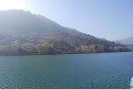
Nainital is named for its beautiful lake Naini
and it is the base for tourism at here. This lake is called Naini because it
look like eye shape. This Lake is famed among the visitors, tourists and nature
lovers for yachting and boating. The southern end area of the lake is called
Tallital and the northern end area is called Mallital. Both the areas have
pretty cottages, luxuries hotels, villas, restaurants, food jones, shopping
centers, game parlors and luxury shops. Other place, Naina Peak (6 kms) an
other popular picnic spot is at a height of 2,610 metres. Fron the Naina Peak
one can have breathtaking view of the Himalayas and entire lake region down the
hill. Among the various temples, Naina Devi Temple is most famous and is
situated on the northern shore of Naini Lake. The presiding goddess of this
temple is “Maa Naina Devi”. Tourists visiting Nainital could also enjoy the Ropeway
which is established by Kumaon Mandal Vikas Nigam. It is one of the advanced ropeways
of India. The Ropeway is controlled electronically and mechanically both. It is
used to carry 12 persons in a single time. Hanumangarhi located at
distance of 3.2 kms from the city is famous for the Hanuman temple and the
spectacular sun-set view from here.
Places
of Interest around Nainital
Bhimtal
Lake
Bhimtal is 25 kms far from Nainital. The famous
five Pandavas of ‘Mahabharata’ came there and one of them named “Bhim” killed a
devil on this place. So it is called Bhimtal. The main attraction of this place
is an island in the center of the lake. This lake offers Boating, swimming and
fishing. All luxuries facility for the tourist is available here.
Naukuchia
Lake
It is 4 kms far form Bhimtal and 26 kms from
Nainital. This lake is called so because of its nine corners. Migratory birds
flock to the lake. This is an ideal place for relaxation and to spend your
holidays
Mukteshwar (50
kms)
This small hill station amidst thick wooded
forest affords majestic view of the Himalayas. Nearby is a stone hole of Chauli
Ki Jali, dedicated to Lord Shiva.
Corbett
National Park
The magnificent park established way back
in 1936, is one of the best known sanctuaries of India. It is named after Jim
Corbett, the famous hunter author and conservator.
Pilgrimage
and Temples in Uttarakhand
Gangotari
Temple

Gangotari, the origin of the River Ganges and
seat of the goddess Ganga, is one of the four sites in the Char Dham,
pilgrimage circuit. Gangotari is located at at distance of 99 kms from Uttarkashi
District of Uttarakhand, approximately 300 kms from Dehradun and 250 kms from
Rishikesh. Couched in the magnificent Garhwal hills, Gangotri is at an altitude
of 3048 meters above sea level. It is on the northernmost part of the state of Uttrakhand and is very near the Indo-Tibetan
border. The summers are relatively cool and winters are freezing cold, with
rains in the months of May and June. For the devotees and tourists, the gates
of the temple are open only in the months of May to November
The river Ganges originates from here and is
called Bhagirathi at the source and acquires the
name Ganga (Ganges) from Devprayag onwards where it meets the
Alaknanda. The origin of the holy river is at Gaumukh, set in the Gangotri
Glacier , and is a 19 km trek from Gangotri. Gangotri can be reached
in one day's travel from Rishikesh, Haridwar or Dehradun, or in two days from
Yanunotri, the first site in the Char Dham circuit. More popular and important
than its sister site to the east, Gangotri is also accessible directly by car
and bus, meaning that it sees many more pilgrims than Yamunotri.

This small town is centered around a temple of
the goddess Ganga , which was built by the Nepalese General, Amar
singh Thapa in the early 18th century. It is visited by lakhs of pilgrims
every year. A number of ashrams are located on the other side, some of which
provide accommodation facilities to the visitors. Ritual duties are supervised
by the Semwal family of priests. The aarti ceremony at the Gangotri is
especially impressive, as is the temple, a stately affair that sits on the
banks of the rushing Ganges. Adventurous pilgrims can make an overnight
18 km trek to Gaumukh, the actual current source of the river Ganges. For
a large number of tourists, Gangotri town serves as the starting point of the
Gangotri-Gaumukh - Tapvan and Gangotri- Kedartal trekking routes.
Badrinath
Temple
The Hindu’s holy Badrinath Dham is located in
the state of Uttarakhand of Himalayan Mountains. It has an average elevation of
3,415 metres (11,204 feet). Badrinath is above the Alaknanda River,
headstream of the holy Indian River ‘Ganges’. The town lies between the Nar and
Narayana mountain ranges and in the shadow of Nilkantah peak (6,560m).
Badrinath is located 301 km north of Rishikesh. From Gaurikund (near
Kedarnath) to Badrinath by road is 233 km.

Badrinath town has cropped on the basis of Badri
Van, where the lush green Badri trees grows. Badri refers to a berry that
was said to grow abundantly in the area and Lord Vishnu survived on during his
reparation at Badri Van, and nath means "Lord of". Badri is
also the Sanskrit name for the Indian Jajube tree, which has an edible
berry. Some scriptural references refer to Jujube trees being abundant in
Badrinath.
Badrinath is an 8th century monastery and a
temple to the Hindu god Shiva. Badrinath was re-established as a major
pilgrimage site by Adi Shankara in the ninth century. Millions of devotees
visit this place every year. The temple in Badrinath is also a sacred
pilgrimage site for Vaishnavites.
Badrinath has been mentioned as a holy place in
scriptures and legends for thousands of years. According to the Bhagavata
Purana, "There in Badrikashram the supreme being (Vishnu), in his
incarnation as the sages Nara and Barayana, had been undergoing great penance
since time immemorial for the welfare of all living entities." (Bhagavata
Purana 3.4.22)

The Badrinath Temple is the main attraction in
the town. According to legend Shankara discovered a black stone image of Lord
Badrinarayan made of Saligram stone in the Alaknanda River. He originally
enshrined it in a cave near the Tapt Kund hot springs. In the sixteenth
century, the King of Garhwal moved the deity to the present temple.
The temple has undergone several major
renovations because of age and damage by avalanche. In the 17th century,
the temple was expanded by the kings of Garhwal. After significant damage in
the great 1803 Himalayan earthquake, it was rebuilt by the King of Jaipur.
The temple is approximately 50 ft (15 m)
tall with a small cupola on top, covered with a gold gilt roof. The facade
is built of stone, with arched windows. A broad stairway leads up to a tall
arched gateway, which is the main entrance. The architecture resembles a
Buddhist vihara (temple), with the brightly painted facade also more typical of
Buddhist temples. Just inside is the mandapa , a large pillared hall
that leads to the garbha griha , or main shrine area. The walls and
pillars of the mandapa are covered with intricate carvings.
The area around Badrinath was celebrated in
Padma Purana as abounding in spiritual treasures.
Glaciers
of Uttarakhand
Gangotri
Glacier
Gangotari, the origin of the sacred river
Ganges, is a famous glacier in Garhwal division of the Uttarakhand, located in
Uttarkashi district. Gangotri glacier originates at the northern angle of
Chaukhamba range of peak. This Glacier is one of the largest in the Himalayas
with an estimated volume of over 27 cubic kilometers. The Glacier is about 30
kilometers long and 2 to 4 kms wide. Gangotri Glacier is not a solitary valley
glacier, but it is a grouping of various other glaciers that are feed to it and
form a huge accumulation of ice. Around the glacier are the peaks of the
Gangotri Group, including several peaks notable for extremely challenging
climbing routes, such as Shivling, Thalay Sagar, Meru, and Bhagirathi III. It
flows roughly northwest, originating in a cirquie below
Chaukhamba, the highest peak of the group.

It is one of the most significant glaciers in Garhwal district as it is dependable for feeding the head tributary of the holy river Ganga.
The terminus of the Gangotri Glacier is
said to resemble a cow’s mouth, and the place is called
Gomukh or Gaumukh. Gomukh, which is about 18 km (11.2 mi)
from the town of Gangotri, is the precise source of the Bhagirathi River, an
important tributary of the Ganges. Gomukh is situated near the base of
Shivling; in between lies the Tapovan meadow.
The Gangotri glacier is a traditional Hindu
Pilgrimage site. Devout Hindus consider bathing in the icy waters near
Gangotri town to be a holy ritual, and many make the trek to Gomukh and
Tapovan.
Gangotri glacier flows at a moderate gradient
apart from for a few ice stockade and crevices developed in the higher regions
of the glacier where, as in the lower part of the glacier is roofed by
fragments, which imparts a grubby emergence to its surface. Gangotri glacier is
straightforwardly accessible. It is well linked by motor able road up to
Gangotri temple and from there a 17kms, long restrain path follows along the
right bank of the Bhagirathi river to Gaumukh, the nose of the glacier.
Pindari
Glacier
The Pindari Glacier is a glacier found
in the upper reaches of the Kumaon Himalayas in the Bageshwar constituency of
Almora District, is placed between the Nanda Devi and Nandakot Peaks. The
Glacier is placed at an altitude of 3627 meter. The glacier flows to the south
for a short distance of about 3 km (1.9 mi) and gives rise to the
Pindari River which meets the Alakananda at Karnaprayag in Garhwal District. The
trail to reach the glacier crosses the villages of Saung, Loharkhet, crosses
over the Dhakuri Pass, continues onto Khati village (the last inhabhited
village on the trail), Dwali, Phurkiaand, finally Zero Point, Pinder the end of
the trail. Though most of the trail is along the banks of the Pindari River,
the river is mostly hidden until after Khati.

The Pindari Glacier trail provides for a
90 km (56 mi) round-trip trek that most people find comfortable to
complete in five days.
As one trek down the route encircled by the
majestic Himalayas, every movement becomes a spanking new tune of nature and at
every arc the eyes hold a new countryside more striking than before. It is one
of the most effortlessly reachable of all the Himalayan glaciers. Pindari's
jagged loveliness offers a remarkable sight, particularly for the trekker who
is in be in love with nature in all its immaculate beauty.
Trekking in Pindari Glacier is well within
the ability of any trekker, amply compensated by splendor of the majestic
dignity of the Himalayas, the attractiveness of mountain flora and fauna, the
snowy ranges, gurgling hill torrents and thunderous water-falls and the rays of
the morning sun splitting into diverse shadowy hues, making evident every drop
of dew on every blade of grass while in the distance, over the mountains, come
the melancholic notes of a shepherds’ flute. The incredible wealth of colour
and attractiveness never ceases to amaze, as with every curve of a twisty
stream, and every corner rounded is present a new scene.